Why sailing in the Isle of Scilly is such a special experience.
- Geological Overview
- Wildlife Overview
- Cultural Overview
- Sailing Overview
Geological Overview
A brief guide to Scilly’s 290 million year history
Where did the Isles of Scilly come from?
Underground
The Isles of Scilly are ancient granite outcrops, formed around 290 million years ago. They began as part of a vast underground body of molten rock—known as a pluton—stretching 10 km beneath what was then the seabed.
At the time, this molten granite lay buried under layers of sandstone and mudstone, sediments that had settled at the bottom of a long-lost sea along the southern edge of Britain. Over millions of years, the landscape shifted, the granite cooled and solidified, and the overlying sediments eroded away, eventually revealing the rugged islands we see today.
What’s in the granite
The Scillonian molten granite solidified very, very slowly , a process which took millions of years. The chemical composition of the granite shows that it was formed from rocks that melted deep in the Earth’s crust.
When molten, the cooling granite was stressed by Earth movements, leading to flow and alignment of crystals that formed early in the granite. Similar movements after it had solidified made cracks and joints. In some places, minerals crystallised out from fluids injected into the cracks.
Over much of Cornwall these fluids contained commercially valuable metals, such as tin and copper. The Scilly pluton is unusual as it seems to lack these metal ores, but it does have veins of white quartz and black fibrous tourmaline.
Fate of the sandstone and mudstone that covered the granite
The hot granite pluton cooked and altered the older sandstone and mudstone “country rocks” as it rose up into them. Later, uplift and erosion of southwest England exposed the altered rock and the Scilly granite. Because of the millions of years of erosion, you would have to dive down to the seabed offshore to see the country rock in place, but you can find pieces of the red sandstone and grey mudstone rock as pebbles on some beaches in Scilly.
Siltstone erratic
As they eroded away, fragments of the country rocks that once overlay the granite pluton were transported as far as Devon, Dorset and Hampshire, where they formed new sedimentary layers of rock, embedding dinosaur skeletons.
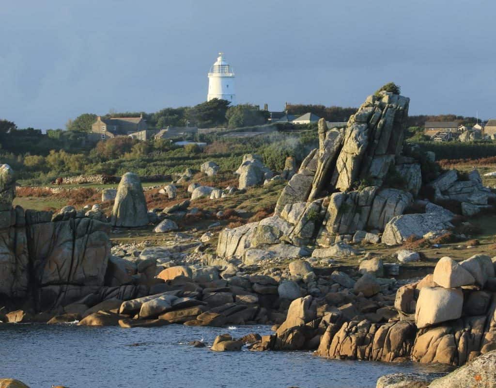
The erosive powers of the wind and sea also sculpted dramatic granite rock formations in Scilly, and provided the white quartz and milky feldspar grains in the sandy beaches.
The Last Ice Age
During the last Ice Age, 21,000 years ago, a large glacier flowed southwards down the Irish Sea Basin reaching as far as the northern extremities of Bryher, Tresco and St Martin’s.
The northern glacial deposits contain flint eroded from the floor of the Irish sea; this resource was used locally in Stone Age times to make tools. Some of these tools are on display in the museum, on St Mary’s.
The moraines at the north end of St Martins (Pernagie bar and White Island bar) provide visible evidence of the southern tip of this glacier. South of this ice limit, cold tundra conditions resulted in the accumulation of orange-brown deposits known locally as “ram”.
This ram is still visible in the cliffs around the islands. In places, the ram contains organic deposits including pollen of tundra plants, radiocarbon dated to the interval between 21,000 and 30,000 years ago.
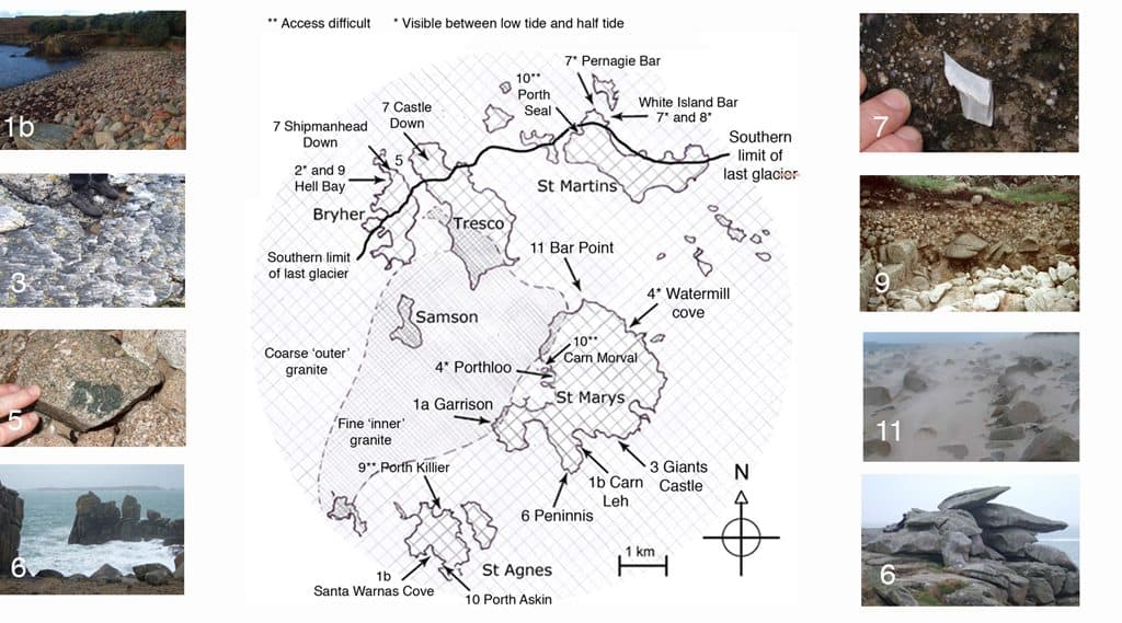
Image courtesy http://naturalhistoryofscilly.info.websitebuilder.prositehosting.co.uk/geology-tour
Climate change
As the climate warmed and the ice melted, it would initially have been possible to walk from Scilly to Cornwall, South Wales, Brittany, and Ireland, but eventually sea levels rose, forming a large single island, and ultimately the archipelago we see today.
Wildlife overview
What makes Scilly special for wildlife?
The Isles of Scilly has a unique assembly of native, migrant and introduced species. The sea surrounding Scilly isolates it from mainland Britain and the warm Gulf Stream keeps the islands frost-free.
In three areas around Scilly – the Irish Sea Front, the Ushant Front and the Continental Shelf – cold nutrient-rich waters mix with the warmer water of the North Atlantic Drift current. (This explains why contrary to expectations the Scillies is not a warm place to swim!)
The combination of warmth and nutrients encourages the growth of phytoplankton (microscopic plants) which are a rich food source for planktonic animals and turns these three areas into feeding grounds for fish, sea birds and sea mammals living in and around Scilly.
Crystal Clear Waters
However, the tidal currents that circle round Scilly isolate it from these feeding grounds and Scilly lacks any rivers or estuaries to fertilize the coastal water. These geographical features account for the clear blue of the sea and limit the numbers of seashore species; they also hamper attempts to farm mussels and oysters here.

The history behind Scilly’s wildlife
In the last Ice Age, 20,000 years ago, the Atlantic coast was 100 km west of Scilly. At that time, Scilly, Ireland, Britain, mainland Europe and Scandinavia were all joined. An ice sheet covered most of Britain, just reaching the north ends of Tresco and St Martins. The plants and animals that lived where the Scillies are now were characteristic tundra wildlife and some of these, lichens, Dwarf Pansy, Greater Tussock Sedge and Red barbed ant remain in the islands.
After the last Ice Age, changes in climate and sea level isolated Scilly, first from continental Europe and then from mainland Britain, restricting the numbers of land animals and allowing some species to evolve separately and differently, giving rise to unique species special to Scilly (endemic species).
Since Neolithic times, human activity has linked Scilly with the rest of the world, importing alien species, both accidentally and intentionally, creating the extraordinary array of plants and animals that thrive in the comparative warmth offered by the North Atlantic Drift current.
These features of Scilly’s geography and history have shaped Scilly’s flora and fauna so that the wildlife we see here today covers a complete range from the exclusive, ‘endemic’ species, like the Scilly shrew, through nationally rare species such as the giant gobi, Lesne’s earwig, many lichens, red seaweeds and mosses, to common species such as shore crab and bracken. Scilly also houses what are arguably out-of-place alien imports such as stick insects and the pittosporum trees that are used as windbreaks. The pittosporum trees are also used for the leaves in floral decorations. The trees on the Scillies have been adversely affected by a fungal disease introduced from St Mawes according to local wildlife expert William Wagstaff.
Information on Geology and Wildlife including some photos from The Natural History of Scilly.
http://naturalhistoryofscilly.info.websitebuilder.prositehosting.co.uk/geology
Some comments in italic have been added by Adam Purser
Cultural Overview
Early history
The islands may correspond to the Cassiterides (‘Tin Isles’) believed by some to have been visited by the Phoenicians, and mentioned by the Greeks. However, the archipelago itself does not contain much tin.
The isles were off the coast of the Brittonic Celtic kingdom of Dumnonia and later its offshoot, Kernow (Cornwall), and may have been a part of these polities until their conquest by the English in the 10th century AD.
It is likely that until relatively recent times the islands were much larger and perhaps joined together into one island named Ennor. Rising sea levels flooded the central plain around 400–500 AD, forming the current 55 islands and islets, if an island is defined as “land surrounded by water at high tide and supporting land vegetation. The word Ennor is a contraction of the Old Cornish En Noer (Moer, mutated to Noer), meaning ‘the land’ or the ‘great island’.
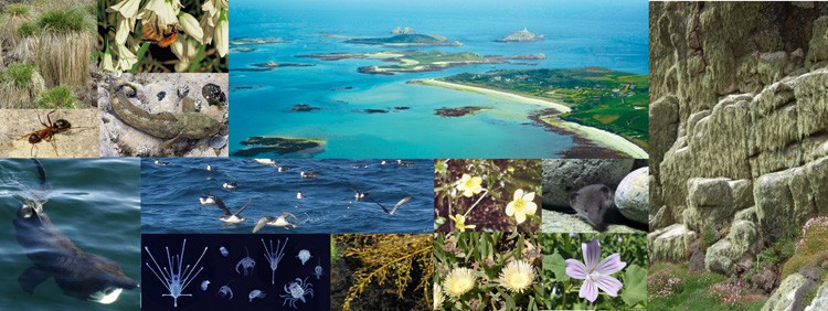
Photo courtesy http://naturalhistoryofscilly.info.websitebuilder.prositehosting.co.uk/wildlife
Evidence for the older large island includes:
A description written during Roman times designates Scilly “Scillonia insula” in the singular, indicating either a single island or an island much bigger than any of the others.
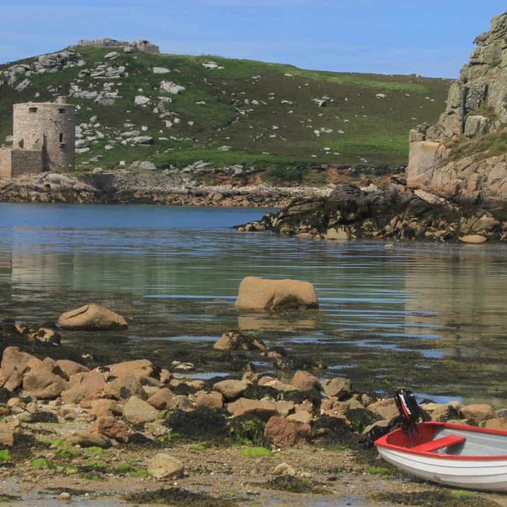
Remains of a prehistoric farm have been found on Nornour, which is now a small rocky skerry far too small for farming. Which you may be able to visit by dinghy. There once was an Iron Age British community here that extended into Roman times. This community was likely formed by immigrants from Brittany, probably the Veneti who were active in the tin trade that originated in mining activity in Cornwall and Devon.
At certain low tides the sea becomes shallow enough for people to walk between some of the islands. It is doable if you are over 6ft tall and don’t try walking to St Agnes, Tresco to Bryher is the easiest to do and only involves shallow wading .
Ancient field walls are visible below the high tide line off some of the islands (e.g. Samson and Brhyer).
Some of the Cornish language place names also appear to reflect past shorelines, and former land areas.
The whole of southern England has been steadily sinking in opposition to post-glacial rebound in Scotland: this has caused the rias (drowned river valleys) on the southern Cornish coast, e.g. River Fal and the Tamar Estuary.
Offshore, midway between Land’s End and the Isles of Scilly, is the supposed location of the mythical lost land of Lyonesse, referred to in Arthurian literature, of which Tristan is said to have been a prince. This may be a folk memory of inundated lands, but this legend is also common among the Brythonic peoples; the legend of Ys is a parallel and cognate legend in Brittany as is that of Cantre’r Gwaelod in Wales.
Scilly has been identified as the place of exile of two heretical 4th century bishops, Instantius and Tiberianus, who were followers of Priscillian. More on that below.
English rule
At the time of King Cnut, the Isles of Scilly fell outside England’s rule, as did Cornwall and Wales.
In 995, Olaf Tryggvason became King Olaf I of Norway. Born c. 960, Olaf had raided various European cities and fought in several wars. In 986 he met a Christian seer on the Isles of Scilly. He was probably a follower of Priscillian and part of the tiny Christian community that was exiled here from Spain by Emperor Maximus for Priscillianism. (A very strict from of asceticism, abstinence from sensual pleasures.) (Is there any significance that the word Priscillian contains Scillian?)
The Normans
With the Norman Conquest, the Isles of Scilly came more under centralised control. About 20 years later, the Domesday survey was conducted. The islands would have formed part of the “Exeter Domesday” circuit, which included Cornwall, Devon, Dorset, Somerset, and Wiltshire.
Vikings
In the mid-12th century, there was reportedly a Viking attack on the Isles of Scilly, called Syllingar by the Norse, recorded in the Orkneyinga saga— Sweyn Asleifsson “went south, under Ireland, and seized a barge belonging to some monks in Syllingar and plundered it.”
…the three chiefs—Swein, Þorbjörn and Eirik—went out on a plundering expedition. They went first to the Suðreyar [Hebrides], and all along the west to the Syllingar, where they gained a great victory in Maríuhöfn on Columba’s-mass [9th June], and took much booty. Then they returned to the Orkneys.
“Maríuhöfn” literally means “Mary’s Harbour/Haven”. The name does not make it clear if it referred to a harbour on a larger island than today’s St Mary’s, or a whole island.
Aethelstan and the English
It is generally considered that Cornwall, and possibly the Isles of Scilly, came under the dominion of the English Crown late in the reign of Æthelstan (AD 924–939). In early times one group of islands was in the possession of a confederacy of hermits. King Henry I (AD 1100–35) gave it to the abbey of Tavistock who established a priory on Tresco, which was abolished at the Reformation.
Later Middle Ages and early modern period
Scilly was one of the Hundreds of Cornwall (formerly known as Cornish Shires) in the early 19th century.
At the turn of the 14th century, the Abbot and convent of Tavistock Abbey petitioned the king, stating that they hold certain isles in the sea between Cornwall and Ireland, of which the largest is called Scilly, to which ships come passing between France, Normandy, Spain, Bayonne, Gascony, Scotland, Ireland, Wales and Cornwall: and, because they feel that in the event of a war breaking out between the kings of England and France, or between any of the other places mentioned, they would not have enough power to do justice to these sailors, they ask that they might exchange these islands for lands in Devon, saving the churches on the islands appropriated to them.
Wrecking
William le Poer, coroner of Scilly, is recorded in 1305 as being worried about the extent of wrecking in the islands, and sending a petition to the King. The names provide a wide variety of origins, e.g. Robert and Henry Sage (English), Richard de Tregenestre (Cornish), Ace de Veldre (French), Davy Gogch (possibly Welsh, or Cornish), and Adam le Fuiz Yaldicz (Spanish?).
It would be interesting to know how they went about wrecking as it indicates they had some method of enticing ships ashore. So where there lighthouses on the Scillies in those times? Was there an even older lighthouse on St Agnes
The Cornish Language
It is not known at what point the islanders stopped speaking the Cornish language, but the language seems to have gone into decline in Cornwall beginning in the Late Middle Ages; it was still dominant between the islands and Bodmin at the time of the Reformation, but it suffered an accelerated decline thereafter. The islands appear to have lost the old Celtic language before parts of Penwith on the mainland, in contrast to the history of Irish or Scottish Gaelic.
English Civil War
During the English Civil War, the Parliamentarians captured the isles, only to see their garrison mutiny and return the isles to the Royalists. By 1651 the Royalist governor, Sir John Grenville, was using the islands as a base for privateering raids on Commonwealth and Dutch shipping. The Dutch admiral Maarten Tromp sailed to the isles and on arriving on 30 May 1651 demanded compensation. In the absence of compensation or a satisfactory reply, he declared war on England in June. It was during this period that the Three Hundred and Thirty Five Years’ War started between the isles and the Netherlands. A Peace Treaty was signed on April 17th 1986.
In June 1651, Admiral Robert Blake recaptured the isles for the Parliamentarians. Blake’s initial attack on Old Grimsby failed, but the next attacks succeeded in taking Tresco and Bryher. Blake placed a battery on Tresco to fire on St Mary’s, but one of the guns exploded, killing its crew and injuring Blake. A second battery proved more successful. Subsequently, Grenville and Blake negotiated terms that permitted the Royalists to surrender honourably. The Parliamentary forces then set to fortifying the islands. They built Cromwell’s Castle—a gun platform on the west side of Tresco—using materials scavenged from an earlier gun platform further up the hill. Although this poorly sited earlier platform dated back to the 1550s, it is now referred to as King Charles’s Castle.
The Isles of Scilly served as a place of exile during the English Civil War. Among those exiled there was Unitarian Jon Biddle.
Largest peace time Naval Tragedy
During the night of 22 October 1707, the isles were the scene of one of the worst maritime disasters in British history, when out of a fleet of 21 Royal Navy ships headed from Gibraltar to Portsmouth, six were driven onto the cliffs. Four of the ships sank or capsized, with at least 1,450 dead, including the commanding admiral Sir Cloudesley Shovell.
It was this event that prompted the British government to create a Board of Longitude empowered to award £20,000 to the first man who developed a chronometer with which longitude could be calculated within half a degree at the end of a voyage to the West Indies.
This was won by John Harrison’s No 4 clock but it took many years of argument to allow him the prize because he was not considered a gentleman. Stupid British upper class!
Tsunami
There is evidence for inundation by the tsunami caused by the 1755 Lisbon earthquake.
Barbary Pirates
The islands appear to have been raided frequently by Barbary pirates to enslave residents to support the Barbary slave trade.
Cultural History Information from – https://en.wikipedia.org/wiki/Isles_of_Scilly
Some comments in italic have been added by Adam Purser
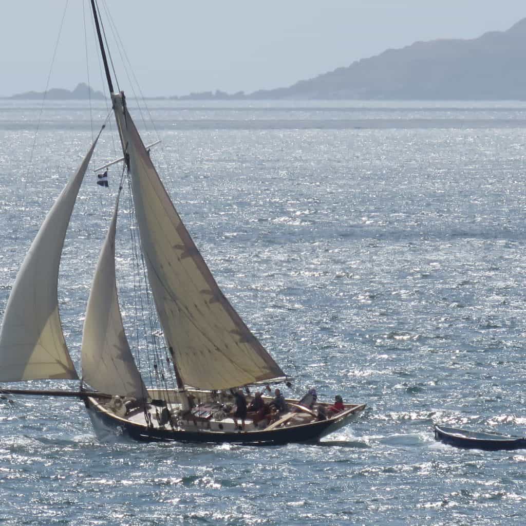
Sailing overview
Classic Sailing’s and the Isles of Scilly
A granite archipelago where the boundary between the land and sea is re-drawn with every tide. The Isles of Scilly are part of Cornwall, but have an island culture and climate shaped by its geological history, the Atlantic Ocean, and the warming Gulf stream.
Interesting Tidal Navigation & Offshore Passage
You could just participate in the steering and sail handling and let the professional crew take you to the Scillies, but there is plenty to learn to if you want more involvement. A voyage to the Scillies has everything a keen sailor or adventurous beginner could want.
No experience is required and most people come on their own – but certain vessels may be more suited to families, beginners or couples. Just get in touch and we can help point you in the right direction – Contact Us.
Sailing to the Isles of Scilly
What to do ashore on Bryher and Samson
.
Voyages to the Isles of Scilly.


